Assignment 3: GPS Track Analysis
Objectives
- to implement a list ADT
- to use opaque
structs
Introduction

Many species of fish have been overfished, threatening their ecosystems and causing economic hardship to the communities that rely on them. International agreements to limit fishing have allowed some fisheries to recover, but illegal fishing remains a problem. Global Fishing Watch monitors the global commercial fishing fleet in near real-time, receiving signals from beacons on the vessels it monitors and recording a GPS track. As the vessels move around the globe, different receivers may record different parts of the track for a particular vessel. For complete analysis, the different track segments received by different receivers must be combined into a single complete track. Once the track has been combined, we can perform further analysis, for example comparing two tracks from different vessels to determine their closest approach to each other – two vessels that have a very close approach may warrant further investigation for transferring illegal catch from one vessel to another.
Assignment
As a basis for others to work with GPS tracks, implement thetrack module by creating the implementation file
track.c. Your implementation must define the functions and
structures declared in the track.h header file found
in /c/cs223/hw3/Required/. For parameters
and return values for the functions, times are in seconds
since a fixed epoch, latitudes and longitudes are in degrees, and
distances are in kilometers. The other pre- and post-conditions
for the functions in the track module
are documented in the header file.
You will also need the more_math, location,
and trackpoint
modules defined by the corresponding .c and .h files
in that same directory.
The location module defines
operations on geographic locations specified by latitudes and longitudes.
The trackpoint module defines operations on GPS trackpoints,
which are locations with timestamps, corresponding to the locations
where a tracked object was observed and the time at which is was
observed there. The trackpoint module also defines
operations on GPS track
segments, which are two consecutive trackpoints recorded for the same
tracked object. The track module that you must complete
defines operations
on complete GPS tracks, which are arbitrarily long sequences of
trackpoints for the same tracked object, in increasing order by timestamp.
After completing the track module,
write a program called GPS that performs
one of two operations on GPS tracks depending on the command-line arguments.
There will be three command-line arguments. The first
will be -combine or -closest to indicate
whether to combine multiple GPS tracks into one or to determine
the closest approach of two tracks. The remaining two command-line
arguments will be the names of files containing the tracks
to work with. Both filenames will be valid (the files will be present
and openable for reading) and distinct.
Each file will contain one trackpoint per line,
with each trackpoint given as latitude and longitude (as decimal degrees),
and a time (in seconds since a chosen epoch), in that order and
with each field in a form suitable for input to strtod
and separated by a single space. There will a newline at the end of each
trackpoint and no other whitespace on any line. The input will be ordered
by strictly increasing time.
For the -combine option, the tracks contained
in the two files should be combined into a single track.
That single track should
contain all the trackpoints from the individual tracks,
ordered by increasing time. If some trackpoints are duplicated across
the two tracks, then the result should contain only one copy. If there
are trackpoints with the same timestamp but different locations, the
resulting combined track should contain neither of those trackpoints.
The program should write the combined GPS track to standard output
in same format as the input files, with all values written with six digits
after the decimal point and with the last digit rounded.
For the -closest argument, the program should write
to standard output the closest
approach of the two tracks, rounded to the nearest kilometer
(or inf if there is no overlap in time bewteen
the two tracks).
"Closest approach" is defined as the minimum distance over all
recorded timestamps that are
between (inclusive) the start and end times of both tracks,
where the location along one track is determined by linear interpolation
separately on the latitudes and longitudes of the next earliest and latest
trackpoints if that track does not contain a trackpoint with a timestamp
that is present in the other. The distance between two points
should be calculated with location_distance from the
location module.
Your implementations of the functions in the track library
must run in the following worst-case time bounds (all bounds exclude the time
for calls to malloc and free).
-
track_create: $O(1)$ -
track_sizeandtrack_length: $O(1)$ -
track_add_point: $O(1)$ -
track_destroyandtrack_get: $O(n)$ -
track_for_each: $O(n)$ plus the time for the calls to the function passed to it -
track_merge: $O(k)$, where $k$ is the number of "overlapping"1 points in the two tracks to merge (if $t_1$ is the track that starts earlier and $t_2$ is the other track, then $k$ is the number of trackpoints in $t_1$ at or after the start of $t_2$ plus the number of trackpoints in $t_2$ at or before the end of $t_1$; if the starting times are the same then $k$ is the total number of points on the two tracks at or before the earlier ending point) -
track_closest_approach: $O(n + m)$, where $n$ and $m$ are the number of points on the two tracks
No specific error messages are required if the files specified
on the command line are not readable, or are not in the correct
format. Your program must not crash or hang if any of the
specifications for the user input (file or command-line) are violated.
The functions in your track module
will not be tested with actual
parameters that violate their preconditions.
Testing
In addition to tests that verify that yourGPS program
works correctly, there is a set of unit tests in track_unit.c
in /c/cs223/hw3/Required that test the individual
functions in the track module. In addition to building
the GPS executable, your makefile must have a rule for
building an executable called TrackUnit from
the provided modules, track_unit.c, track.h,
and your track.c. Your makefile should assume that
the provided files from /c/cs223/hw3/Required
have been copied into the current directory; they will not necessarily
be in their original locations.
Your code will be tested with valgrind,
so make sure there are no memory leaks or other errors reported
by valgrind, including for invalid user input.
Although it
is good practice to error-check malloc calls, we will
not test out-of-memory conditions – there will be sufficient
memory to process all inputs on the Zoo as long as your implementation
of the track module consumes $O(n)$ memory for a trackpoint
of $n$ points (with a reasonable constant hidden by the $O$).
You may assume that the epoch is within human history and that all timestamps are in the range of time from the beginning of modern human history to a time no further in the future than the beginning of modern human history is in the past.
Example
For-combine, consider the track below, where two receivers
each recorded part of the track. The red dots indicate trackpoints
recorded by one receiver and recorded in one file, and the bold outlines
indicate trackpoints recorded by another receiver and recorded in
another file.
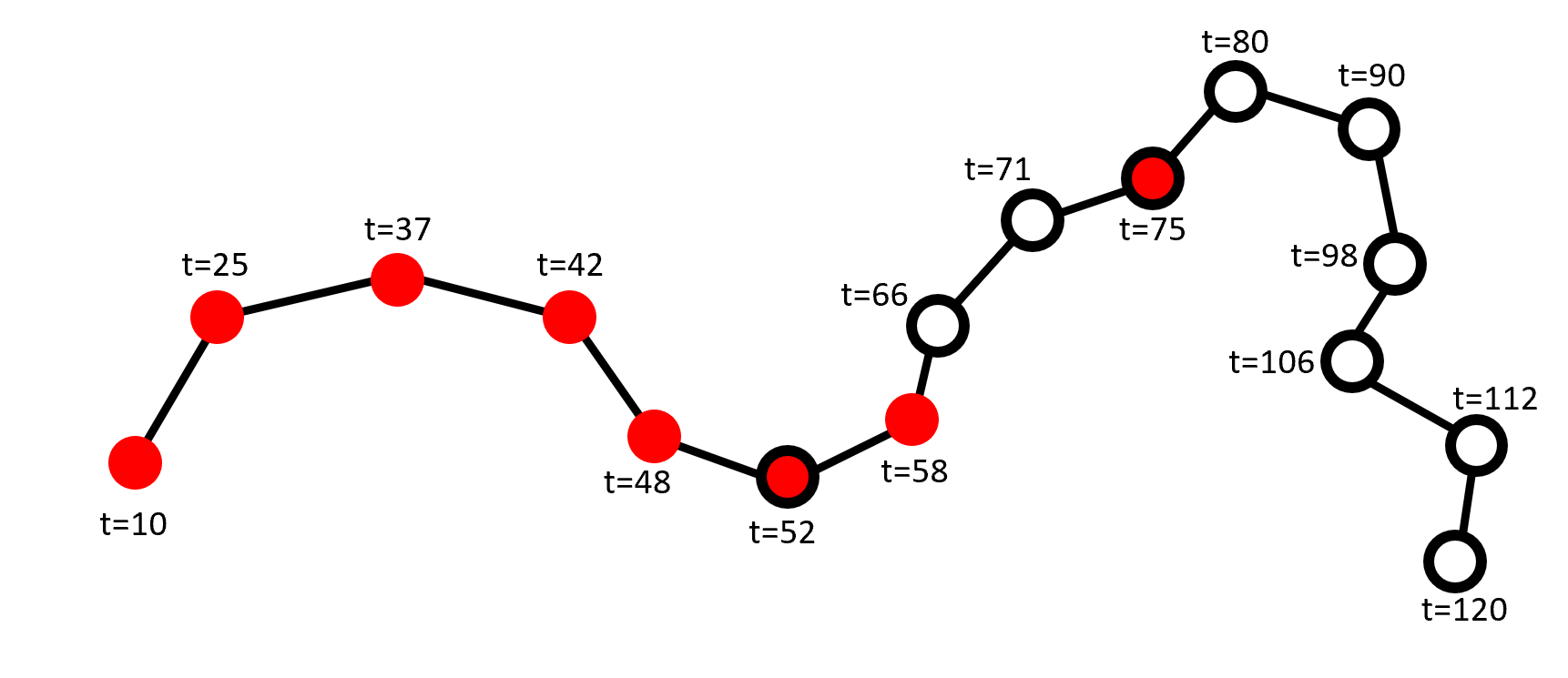
The merged track from the two receivers would contain one copy of each trackpoint. For the purposes of runtime, $k = 7$ in this example: 3 points from the red track (52, 58, 75), and 4 from the bold track (52, 66, 71, 75).
$ cat merge_example_red.in
-23.590 76.148 10.0
-23.349 76.236 25.0
-23.306 76.436 37.0
-23.349 76.623 42.0
-23.480 76.716 48.0
-23.524 76.864 52.0
-23.460 77.003 58.0
-23.194 77.266 75.0
$ cat merge_example_bold.in
-23.524 76.864 52.0
-23.359 77.030 66.0
-23.241 77.134 71.0
-23.100 77.353 80.0
-23.142 77.502 90.0
-23.292 77.523 98.0
-23.397 77.483 106.0
-23.488 77.620 112.0
-23.617 77.595 120.0
$ ./GPS -combine merge_example_red.in merge_example_bold.in
-23.590000 76.148000 10.000000
-23.349000 76.236000 25.000000
-23.306000 76.436000 37.000000
-23.349000 76.623000 42.000000
-23.480000 76.716000 48.000000
-23.524000 76.864000 52.000000
-23.460000 77.003000 58.000000
-23.359000 77.030000 66.000000
-23.241000 77.134000 71.000000
-23.194000 77.266000 75.000000
-23.100000 77.353000 80.000000
-23.142000 77.502000 90.000000
-23.292000 77.523000 98.000000
-23.397000 77.483000 106.000000
-23.488000 77.620000 112.000000
-23.617000 77.595000 120.000000
For -closest consider the two tracks in the example below,
where the large dots represent recorded trackpoints, and the
smaller dots represent positions interpolated at timestamps present
in one track but not the other. The dashed lines represent the
distances between pairs of points (recorded or interpolated)
with matching timestamps. The closest approach is approximated
as the distance between the trackpoints with timestamp 24.
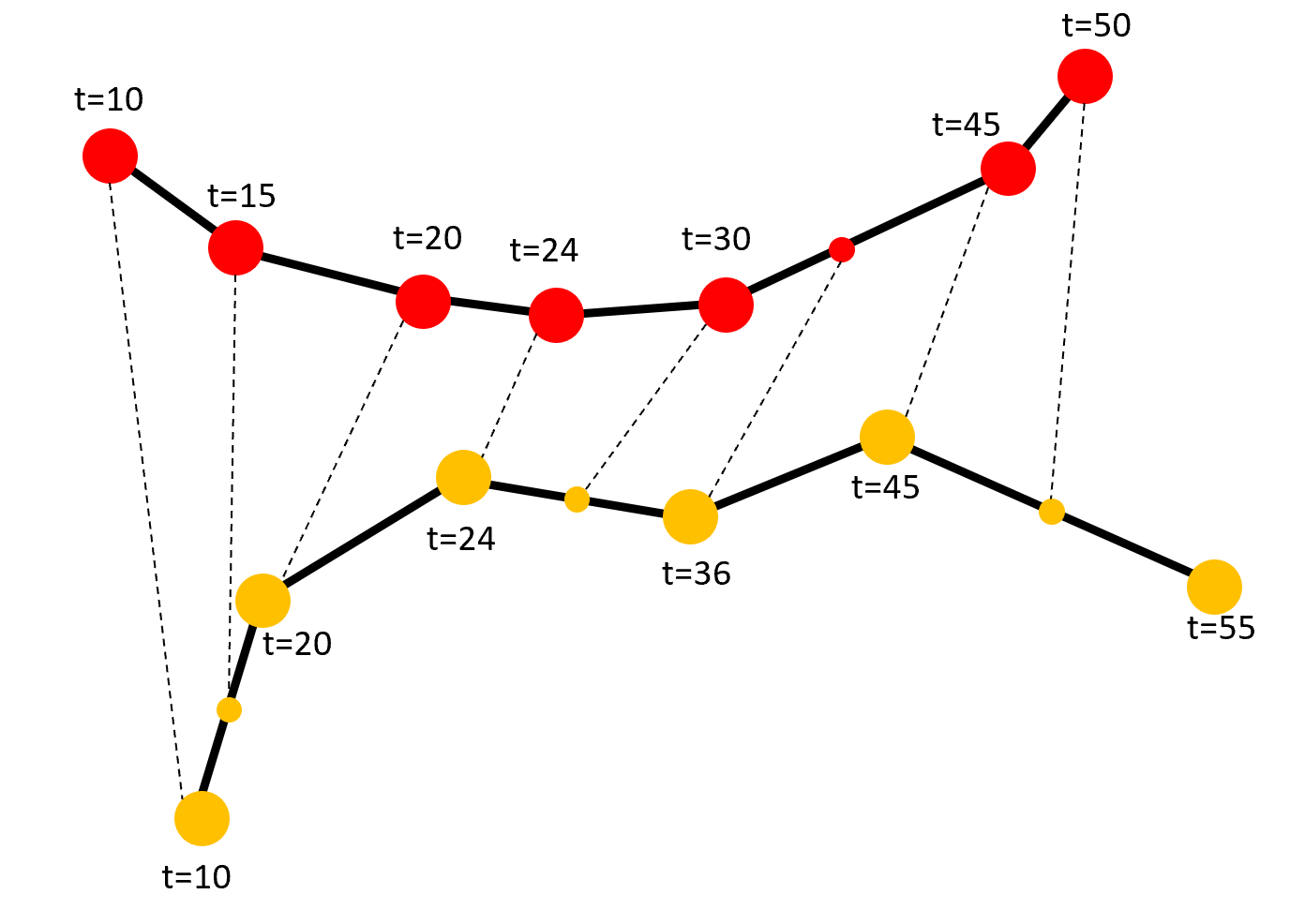
$ cat closest_bottom.in
-30.873 160.212 10.0
-30.643 160.277 20.0
-30.509 160.493 24.0
-30.550 160.733 36.0
-30.463 160.943 45.0
-30.625 161.291 55.0
$ cat closest_top.in
-30.164 160.114 10.0
-30.262 160.247 15.0
-30.322 160.446 20.0
-30.334 160.589 24.0
-30.324 160.773 30.0
-30.179 161.074 45.0
-30.078 161.154 50.0
$ ./GPS -closest closest_top.in closest_bottom.in
21
Submissions
Submit your makefile, log file, and your source code necessary to build the executablesGPS and TrackUnit using your makefile.
Do not submit the provided more_math, location,
and trackpoint modules,
track.h, or track_unit.c.